Supermarket nearby Migros
Switzerland
Supermarket nearby Migros
Migros
Eisengasse 12, Basel Szwajcaria
contacts phone
:
+41
Latitude:
47.5592592
, Longitude:
7.587744
read more
nearest Supermarket
69 m
Pearl Factory Outlet Basel
Marktgasse 16, Basel
Supermarket
read more
200 m
Coop Supermarkt City Basel Marktplatz Food
Hutgasse 19, Basel
Supermarket
read more
207 m
Coop City Basel Marktplatz Food
Hutgasse 19, Basel
Supermarket
read more
330 m
Coop Supermarkt Basel Greifengasse
Greifengasse 3, Basel
Supermarket
read more
448 m
ALDI Basel
Webergasse 34, Basel
Supermarket
read more
459 m
Coop
Freie Strasse 75, Basel
Supermarket
read more
466 m
Coop Supermarkt City Basel Pfauen Food
Freie Strasse 75, Basel
Supermarket
read more
470 m
Coop Pronto Basel Barfüsserplatz
Streitgasse 20, Basel
Supermarket
read more
475 m
Migros
Ochsengasse 2, Basel
Supermarket
read more
482 m
Aldi Suisse
Teichgässlein 30, Basel
Supermarket
read more
519 m
KKiosk
24 Barfüsserplatz Basel
Supermarket
read more
519 m
k kiosk
24 Barfüsserplatz Basel
Supermarket
read more
521 m
Denner
Untere Rebgasse 4, Basel
Supermarket
read more
602 m
Migros
Schützenmattstrasse 27, Basel
Supermarket
read more
674 m
Lidl Schweiz
Clarastrasse 6, Basel
Supermarket
read more
733 m
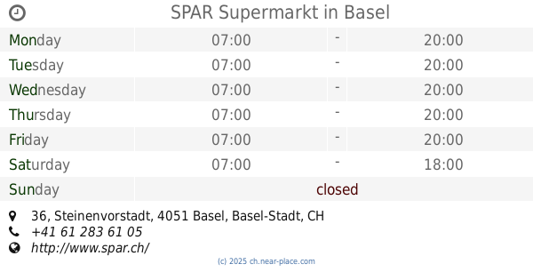
SPAR Supermarkt
Steinenvorstadt 36, Basel
Supermarket
read more
756 m
Erasmus-Lädeli GmbH
Feldbergstrasse 32, Basel
Supermarket
read more
792 m
Tropical Zone
Clarastrasse 30, Basel
Supermarket
read more
797 m
Coop Supermarkt Basel Europe
Clarastrasse 41, Basel
Supermarket
read more
807 m
Migros
Aeschenvorstadt 24, Basel
Supermarket
read more
842 m
Denner
Klybeckstrasse 45, Basel
Supermarket
read more
923 m
Coop Supermarkt Basel Spalemärt
Missionsstrasse 53, Basel
Supermarket
read more
929 m
Kiosk Steinentor
Heuwaage-Viadukt, Basel
Supermarket
read more
994 m
ALDI Basel
Türkheimerstrasse 4-6
Supermarket
read more
1.051 km
Coop Supermarkt Basel Bachletten
Steinenring 45, Basel
Supermarket
read more
📑
all categories
Accounting
Administrative area level 1
Administrative area level 2
Airport
Amusement park
Aquarium
Art gallery
Atm
Bakery
Bank
Bar
Beauty salon
Bicycle store
Book store
Bowling alley
Bus station
Cafe
Campground
Car dealer
Car rental
Car repair
Car wash
Casino
Cemetery
Church
City hall
Clothing store
Colloquial area
Convenience store
Country
Courthouse
Dentist
Department store
Doctor
Electrician
Electronics store
Embassy
Finance
Fire station
Florist
Food
Funeral home
Furniture store
Gas station
General contractor
Grocery or supermarket
Gym
Hair care
Hardware store
Health
Hindu Temple
Home goods store
Hospital
Insurance agency
Jewelry store
Laundry
Lawyer
Library
Light rail station
Liquor store
Local government office
Locality
Locksmith
Lodging
Meal delivery
Meal takeaway
Mosque
Movie rental
Movie theater
Moving company
Museum
Natural feature
Neighborhood
Night club
Painter
Park
Parking
Pet store
Pharmacy
Physiotherapist
Place of worship
Plumber
Point of interest
Police
Political
Post office
Premise
Real estate agency
Restaurant
Roofing contractor
Route
Rv park, camping
School
Shoe store
Shopping mall
Spa
Stadium
Storage
Store
Subpremise
Subway station
Supermarket
Synagogue
Taxi stand
Train station
Transit station
Travel agency
University
Veterinary care
Zoo
administrative area level 3
sublocality level 1
sublocality level 2
↑