Supermarket nearby Denner
Switzerland
Supermarket nearby Denner
Denner
Av. d`Echallens 68, Lausanne Schweiz
contacts phone
:
+41
Latitude:
46.5279283
, Longitude:
6.6169994
read more
nearest Supermarket
63 m
Migros
Avenue d'Echallens 63, Lausanne
Supermarket
read more
364 m
Coop Supermarché Lausanne Prélaz
Avenue de Morges 60, Lausanne
Supermarket
read more
372 m
OTTO'S AG
Avenue d'Echallens 100, Lausanne
Supermarket
read more
395 m
Coop
Avenue Bergières 42, Lausanne
Supermarket
read more
402 m
Migros
Avenue des Bergières 50, Lausanne
Supermarket
read more
547 m
Migros Partner
Rue du Maupas 69, Lausanne
Supermarket
read more
706 m
Migros
Avenue de Sévelin 2, Lausanne
Supermarket
read more
792 m
PAM
Chemin de Pierrefleur 32, Lausanne
Supermarket
read more
888 m
Coop Pronto
Place Chauderon 3, Lausanne
Supermarket
read more
892 m
Migros
Avenue Jomini 11, Lausanne
Supermarket
read more
916 m
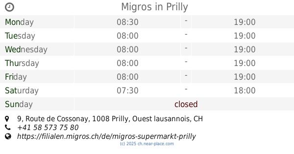
Migros
Route de Cossonay 9, Prilly
Supermarket
read more
956 m
Denner
Rue des Terreaux 25, Lausanne
Supermarket
read more
966 m
Denner
Av. du Grey 58, Lausanne
Supermarket
read more
1.089 km
Coop Commercial Center
Route de Cossonay 28, Prilly
Supermarket
read more
1.103 km
Coop Supermarché Prilly Centre
Route de Cossonay 28, Prilly
Supermarket
read more
1.103 km
Coop Restaurant Prilly Centre
Route de Cossonay 28, Prilly
Supermarket
read more
1.2 km
Denner
Voie du Chariot 4-6, Lausanne-Flon
Supermarket
read more
1.208 km
Migros
Voie du Chariot 4-6, Lausanne
Supermarket
read more
1.232 km
Migros
Rue de la Borde 3B, Lausanne
Supermarket
read more
1.27 km
Denner
Av. de Cour 143, Lausanne
Supermarket
read more
1.488 km
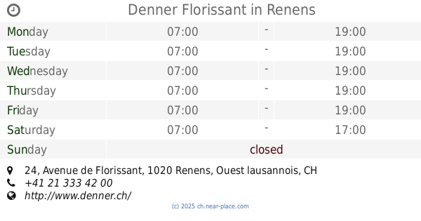
Migros
Avenue de Florissant 38, Renens
Supermarket
read more
1.532 km
Denner
Passage de Montriond 4, Lausanne
Supermarket
read more
1.534 km
Denner
Bd de Grancy 37, Lausanne
Supermarket
read more
1.543 km
Denner Florissant
Avenue de Florissant 24, Renens
Supermarket
read more
1.79 km
Coop Supermarché Lausanne Grancy
Boulevard de Grancy 4, Lausanne
Supermarket
read more
📑
all categories
Accounting
Administrative area level 1
Administrative area level 2
Airport
Amusement park
Aquarium
Art gallery
Atm
Bakery
Bank
Bar
Beauty salon
Bicycle store
Book store
Bowling alley
Bus station
Cafe
Campground
Car dealer
Car rental
Car repair
Car wash
Casino
Cemetery
Church
City hall
Clothing store
Colloquial area
Convenience store
Country
Courthouse
Dentist
Department store
Doctor
Electrician
Electronics store
Embassy
Finance
Fire station
Florist
Food
Funeral home
Furniture store
Gas station
General contractor
Grocery or supermarket
Gym
Hair care
Hardware store
Health
Hindu Temple
Home goods store
Hospital
Insurance agency
Jewelry store
Laundry
Lawyer
Library
Light rail station
Liquor store
Local government office
Locality
Locksmith
Lodging
Meal delivery
Meal takeaway
Mosque
Movie rental
Movie theater
Moving company
Museum
Natural feature
Neighborhood
Night club
Painter
Park
Parking
Pet store
Pharmacy
Physiotherapist
Place of worship
Plumber
Point of interest
Police
Political
Post office
Premise
Real estate agency
Restaurant
Roofing contractor
Route
Rv park, camping
School
Shoe store
Shopping mall
Spa
Stadium
Storage
Store
Subpremise
Subway station
Supermarket
Synagogue
Taxi stand
Train station
Transit station
Travel agency
University
Veterinary care
Zoo
administrative area level 3
sublocality level 1
sublocality level 2
↑