Museum nearby Hall P
Switzerland
Museum nearby Hall P
Hall P
Rütlistrasse 19, Thun Suiza
contacts phone
:
+41
Latitude:
46.7585316
, Longitude:
7.6147193
read more
nearest Museum
188 m
Panzer Museum
Thun
Museum
read more
1.025 km
London-Taxis
Länggasse 62, Thun
Museum
read more
1.171 km
Thun Castle
Schlossberg 1, Thun
Museum
read more
1.278 km
Spielzeugmuseum Thun
Burgstrasse 15, Thun
Museum
read more
1.493 km
Kunstmuseum Thun
Hofstettenstr. 14, Thun
Museum
read more
2.139 km
Dampfbahn Schadaupark
Seestrasse 45, Thun
Museum
read more
2.185 km
Flechtmuseum
Neufeldstrasse 6, Thun
Museum
read more
3.761 km
Music School Thun
Gwatt (Thun), Gwattstrasse 122, Gwatt (Thun)
Museum
read more
3.833 km
Swiss Gastronomy Museum Thun
Im Schloss Hünegg, Staatsstrasse 52, Hilterfingen
Museum
read more
3.834 km
Schloss Hünegg
Staatsstrasse 52, Hilterfingen
Museum
read more
5.194 km
Schloss Oberhofen
3653, Oberhofen
Museum
read more
5.202 km
Sammlung Karl und Jürg Im Obersteg
Staatsstrasse 10, Oberhofen am Thunersee
Museum
read more
5.337 km
Infanteriefestung
3625, Heiligenschwendi
Museum
read more
5.481 km
Museum of Clocks and mechanical musical instruments
Staatsstrasse 18, Oberhofen am Thunersee
Museum
read more
22.241 km
Freimaurer Museum Schweiz
Jupiterstrasse 40, Bern
Museum
read more
24.062 km
Bernisches Historisches Museum / Einstein Museum
Helvetiaplatz 5, Bern
Museum
read more
24.18 km
Kunsthalle Bern
Helvetiaplatz 1, Bern
Museum
read more
24.201 km
Alpines Museum der Schweiz
Helvetiaplatz 4, Bern
Museum
read more
24.547 km
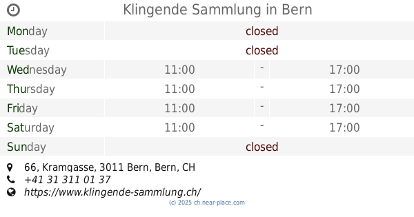
Klingende Sammlung
Kramgasse 66, Bern
Museum
read more
24.695 km
Kornhausforum
Kornhausplatz 18, Bern
Museum
read more
25.081 km
Kunstmuseum Bern
Hodlerstrasse 8, Bern
Museum
read more
25.106 km
SAPA
Schanzenstrasse 15, Bern
Museum
read more
25.169 km
Patriatreppe
Stadtbachstrasse 8A, Bern
Museum
read more
25.42 km
Johanneskirche
Wylerstrasse 5, Bern
Museum
read more
27.211 km
Picturemaker Photography
Reichenbachstrasse 118, Bern
Museum
read more
📑
all categories
Accounting
Administrative area level 1
Administrative area level 2
Airport
Amusement park
Aquarium
Art gallery
Atm
Bakery
Bank
Bar
Beauty salon
Bicycle store
Book store
Bowling alley
Bus station
Cafe
Campground
Car dealer
Car rental
Car repair
Car wash
Casino
Cemetery
Church
City hall
Clothing store
Colloquial area
Convenience store
Country
Courthouse
Dentist
Department store
Doctor
Electrician
Electronics store
Embassy
Finance
Fire station
Florist
Food
Funeral home
Furniture store
Gas station
General contractor
Grocery or supermarket
Gym
Hair care
Hardware store
Health
Hindu Temple
Home goods store
Hospital
Insurance agency
Jewelry store
Laundry
Lawyer
Library
Light rail station
Liquor store
Local government office
Locality
Locksmith
Lodging
Meal delivery
Meal takeaway
Mosque
Movie rental
Movie theater
Moving company
Museum
Natural feature
Neighborhood
Night club
Painter
Park
Parking
Pet store
Pharmacy
Physiotherapist
Place of worship
Plumber
Point of interest
Police
Political
Post office
Premise
Real estate agency
Restaurant
Roofing contractor
Route
Rv park, camping
School
Shoe store
Shopping mall
Spa
Stadium
Storage
Store
Subpremise
Subway station
Supermarket
Synagogue
Taxi stand
Train station
Transit station
Travel agency
University
Veterinary care
Zoo
administrative area level 3
sublocality level 1
sublocality level 2
↑