Gas station nearby Tamoil
Switzerland
Gas station nearby Tamoil
Tamoil
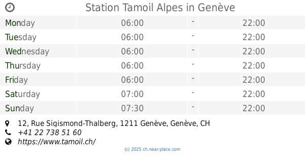
Rue Sigismond-Thalberg 12, Genève Schweiz
contacts phone
:
+41
Latitude:
46.2098803
, Longitude:
6.1464482
read more
nearest Gas station
Station Tamoil Alpes
Rue Sigismond-Thalberg 12, Genève
Gas station
read more
665 m
Parking
Geneva
Gas station
read more
909 m
Lundin SA
Rue de Rive 6, Genève
Gas station
read more
952 m
Station de service AVIA
Geneva
Gas station
read more
1.067 km
BP
Boulevard Helvétique 31Bis, Genève
Gas station
read more
1.096 km
Station Migrol
Rue de Vermont 4, Genève
Gas station
read more
1.211 km
Ed-shop Sarl
Rue du Jeu-de-l'Arc 15, Genève
Gas station
read more
1.234 km
Shell
Rue de Montbrillant 67, Genève
Gas station
read more
1.301 km
Le Duo Coiffeur
Rue Gourgas 4, Genève
Gas station
read more
1.364 km
SOCAR Genève-Charmilles
Rue des Charmilles 22, Genève
Gas station
read more
1.374 km
Avia Genève
Rue des Charmilles 22, Genève
Gas station
read more
1.394 km
Auto Secours
Rue de Montchoisy 70, Genève
Gas station
read more
1.58 km
Tamoil
Route de Frontenex 49, Genève
Gas station
read more
1.58 km
Station Tamoil Frontenex
Route de Frontenex 49, Genève
Gas station
read more
1.623 km
Sarpdoil Geneve Sàrl
Rue de Contamines 16, Genève
Gas station
read more
1.663 km
Coop Pronto Genève Rue de Lyon
Rue de Lyon 100, Genève
Gas station
read more
1.763 km
SOCAR Genève-Malagnou
Route de Malagnou 29, Genève
Gas station
read more
1.832 km
Station Et Shop Rue Dancet, Casonato & Cie
Rue Dancet 10, Genève
Gas station
read more
1.838 km
Station Tamoil Dancet
Rue Dancet 10, Genève
Gas station
read more
1.894 km
Tamoil
Chemin du Petit-Saconnex 2, Genève
Gas station
read more
1.919 km
Shell
Rue Michel-Servet 17, Genève
Gas station
read more
1.931 km
Shell
Chemin du Petit-Saconnex 5, Genève
Gas station
read more
1.949 km
BEBECO Bundestankstelle
Rue Hans Wilsdorf 1, Genève
Gas station
read more
2.04 km
Shell
Avenue Krieg 5, Genève
Gas station
read more
2.046 km
Morandi Pierre
Avenue Krieg 5, Genève
Gas station
read more
📑
all categories
Accounting
Administrative area level 1
Administrative area level 2
Airport
Amusement park
Aquarium
Art gallery
Atm
Bakery
Bank
Bar
Beauty salon
Bicycle store
Book store
Bowling alley
Bus station
Cafe
Campground
Car dealer
Car rental
Car repair
Car wash
Casino
Cemetery
Church
City hall
Clothing store
Colloquial area
Convenience store
Country
Courthouse
Dentist
Department store
Doctor
Electrician
Electronics store
Embassy
Finance
Fire station
Florist
Food
Funeral home
Furniture store
Gas station
General contractor
Grocery or supermarket
Gym
Hair care
Hardware store
Health
Hindu Temple
Home goods store
Hospital
Insurance agency
Jewelry store
Laundry
Lawyer
Library
Light rail station
Liquor store
Local government office
Locality
Locksmith
Lodging
Meal delivery
Meal takeaway
Mosque
Movie rental
Movie theater
Moving company
Museum
Natural feature
Neighborhood
Night club
Painter
Park
Parking
Pet store
Pharmacy
Physiotherapist
Place of worship
Plumber
Point of interest
Police
Political
Post office
Premise
Real estate agency
Restaurant
Roofing contractor
Route
Rv park, camping
School
Shoe store
Shopping mall
Spa
Stadium
Storage
Store
Subpremise
Subway station
Supermarket
Synagogue
Taxi stand
Train station
Transit station
Travel agency
University
Veterinary care
Zoo
administrative area level 3
sublocality level 1
sublocality level 2
↑