Bar nearby Hinz & Kunz
Switzerland
Bar nearby Hinz & Kunz
Hinz & Kunz
Markthalle Basel, Steinentorberg 20, Basel Schweiz
contacts phone
:
+41
Latitude:
47.5492132
, Longitude:
7.5870624
read more
nearest Bar
7 m
Bierrevier
Steinentorberg 20, Basel
Bar
read more
127 m
車站路口Basal
Centralbahnstrasse 4, Basel
Bar
read more
159 m
Buvette Bollwerk
Bollwerk-Promenade 5, Basel
Bar
read more
253 m
Radisson Blu Hotel, Basel
Steinentorstrasse 25, Basel
Bar
read more
261 m
Filini Bar & Restaurant
Steinentorstrasse 25, Basel
Bar
read more
291 m
The Stone (Harrem) Shishabar Lounge
26, Steinentorstrasse, Basel
Bar
read more
307 m
Basel Hotel Victoria
Centralbahnplatz 3-4, Basel
Bar
read more
335 m
Bunker XIII Maniacs MC Basel
Güterstrasse 91, Basel
Bar
read more
371 m
Café Bar Royal
92 Güterstrasse Basel
Bar
read more
523 m
VITO
Güterstrasse 138, Basel
Bar
read more
576 m
Baragraph
10 Kohlenberg Basel
Bar
read more
646 m
Brötli-Bar
Gerbergasse 84, Basel
Bar
read more
681 m
Des Arts
Barfüsserplatz 6, Basel
Bar
read more
718 m
zimmer-frei
Goldbachweg 8, Basel
Bar
read more
733 m
Bar & Kaffee Zum Teufel (im Teufelhof)
Leonhardsgraben 49, Basel
Bar
read more
745 m
Der Teufelhof Basel
Leonhardsgraben 49, Basel
Bar
read more
748 m
Schluggstube Antiquitätenbar
Gerbergässlein 28, Basel
Bar
read more
847 m
Spale Bar
Spalenberg 53, Basel
Bar
read more
864 m
Restaurant Tapas del Mar Spalenburg
Schnabelgasse 2, Basel
Bar
read more
886 m
ONO deli cafe bar
Leonhardsgraben 2, Basel
Bar
read more
898 m
Hotel Basel
Münzgasse 12, Basel
Bar
read more
929 m
Hall Kulebra
Hutgasse 1, Basel
Bar
read more
982 m
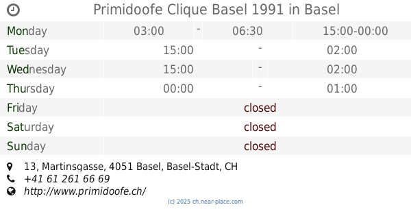
Primidoofe Clique Basel 1991
Martinsgasse 13, Basel
Bar
read more
991 m
Verso
Petersgraben 50, Basel
Bar
read more
998 m
Breo Keller
Nadelberg 10, Basel
Bar
read more
📑
all categories
Accounting
Administrative area level 1
Administrative area level 2
Airport
Amusement park
Aquarium
Art gallery
Atm
Bakery
Bank
Bar
Beauty salon
Bicycle store
Book store
Bowling alley
Bus station
Cafe
Campground
Car dealer
Car rental
Car repair
Car wash
Casino
Cemetery
Church
City hall
Clothing store
Colloquial area
Convenience store
Country
Courthouse
Dentist
Department store
Doctor
Electrician
Electronics store
Embassy
Finance
Fire station
Florist
Food
Funeral home
Furniture store
Gas station
General contractor
Grocery or supermarket
Gym
Hair care
Hardware store
Health
Hindu Temple
Home goods store
Hospital
Insurance agency
Jewelry store
Laundry
Lawyer
Library
Light rail station
Liquor store
Local government office
Locality
Locksmith
Lodging
Meal delivery
Meal takeaway
Mosque
Movie rental
Movie theater
Moving company
Museum
Natural feature
Neighborhood
Night club
Painter
Park
Parking
Pet store
Pharmacy
Physiotherapist
Place of worship
Plumber
Point of interest
Police
Political
Post office
Premise
Real estate agency
Restaurant
Roofing contractor
Route
Rv park, camping
School
Shoe store
Shopping mall
Spa
Stadium
Storage
Store
Subpremise
Subway station
Supermarket
Synagogue
Taxi stand
Train station
Transit station
Travel agency
University
Veterinary care
Zoo
administrative area level 3
sublocality level 1
sublocality level 2
↑