Gas station nearby Migrol Service
Coronavirus disease (COVID-19) Situation
confirmed cases
4453053
deaths
14452
Switzerland
Gas station nearby Migrol Service
Migrol Service
Ruchwiesenstrasse 1, Dielsdorf Schweiz
contacts phone
:
+41
Latitude:
47.4810832
, Longitude:
8.4653703
read more
nearest Gas station
1.457 km
Maag Velos-Motos AG
Dorfstrasse 16, Niederhasli
Gas station
read more
3.041 km
Socar Tankstelle Oberglatt
Kaiserstuhlstrasse 51, Oberglatt
Gas station
read more
3.47 km
Agrola
Niederglatterstrasse, Höri
Gas station
read more
3.624 km
SOCAR Buchs ZH
Eichstrasse 2, Buchs
Gas station
read more
4.482 km
Tamoil
Industriestrasse 12, Dällikon
Gas station
read more
4.716 km
Agrola
Wehntalerstrasse 38, Höri
Gas station
read more
4.889 km
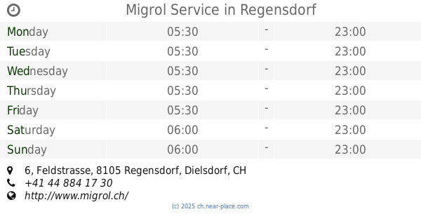
Migrol Service
Feldstrasse 6, Regensdorf
Gas station
read more
5.508 km
BEBECO Bundestankstelle
Waffenplatz, Bülach
Gas station
read more
6.02 km
Station Ing. Greuter Ag
Langmattstrasse 8, Hochfelden
Gas station
read more
6.604 km
Avia Tankstelle
Bächliwis 29, Bachenbülach
Gas station
read more
6.607 km
Migrol Tankstelle
Bächliwis 29, Bachenbülach
Gas station
read more
7.54 km
Agrola
Winterthurerstrasse 46, Bülach
Gas station
read more
9.03 km
Agrola
Grosszelgstrasse, Würenlos
Gas station
read more
9.593 km
Tamoil
Landstrasse 187, Wettingen
Gas station
read more
10.009 km
Shell
A1 Wald, Würenlos
Gas station
read more
10.323 km
Avia - Wettingen
Landstrasse 121, Wettingen
Gas station
read more
10.345 km
Socar
Hagenholzstrasse 119, Opfikon
Gas station
read more
11.013 km
Discount Tankstelle - Zürich
Hönggerstrasse 14, Zürich
Gas station
read more
11.016 km
Scall Tankstelle
Hönggerstrasse 17, Zürich
Gas station
read more
12.766 km
BP Tankstelle Wiedikon
Zürich
Gas station
read more
13.939 km
BP
Badenerstrasse 16, Fislisbach
Gas station
read more
13.996 km
Shell
Zelgweg 17, Baden
Gas station
read more
14.01 km
Shell
Bruggerstrasse 194, Baden
Gas station
read more
15.612 km
BP
Mythenquai 320, Zürich
Gas station
read more
17.817 km
SOCAR Fällanden
Schwerzenbachstrasse 41, Fällanden
Gas station
read more
📑
all categories
Accounting
Administrative area level 1
Administrative area level 2
Airport
Amusement park
Aquarium
Art gallery
Atm
Bakery
Bank
Bar
Beauty salon
Bicycle store
Book store
Bowling alley
Bus station
Cafe
Campground
Car dealer
Car rental
Car repair
Car wash
Casino
Cemetery
Church
City hall
Clothing store
Colloquial area
Convenience store
Country
Courthouse
Dentist
Department store
Doctor
Electrician
Electronics store
Embassy
Finance
Fire station
Florist
Food
Funeral home
Furniture store
Gas station
General contractor
Grocery or supermarket
Gym
Hair care
Hardware store
Health
Hindu Temple
Home goods store
Hospital
Insurance agency
Jewelry store
Laundry
Lawyer
Library
Light rail station
Liquor store
Local government office
Locality
Locksmith
Lodging
Meal delivery
Meal takeaway
Mosque
Movie rental
Movie theater
Moving company
Museum
Natural feature
Neighborhood
Night club
Painter
Park
Parking
Pet store
Pharmacy
Physiotherapist
Place of worship
Plumber
Point of interest
Police
Political
Post office
Premise
Real estate agency
Restaurant
Roofing contractor
Route
Rv park, camping
School
Shoe store
Shopping mall
Spa
Stadium
Storage
Store
Subpremise
Subway station
Supermarket
Synagogue
Taxi stand
Train station
Transit station
Travel agency
University
Veterinary care
Zoo
administrative area level 3
sublocality level 1
sublocality level 2
↑